
 Webcam image of the eruption
Updated 3 December at 16:45 UTC
There has been insignificant change in the eruptive activity of the active vent in recent days, supported by seismic measurements. Lava continues to flow from the active crater, predominantly travelling southeast in the direction of Fagradalsfjall.
Minor changes have occurred at the lava front, but its overall advance has been slow. The crater continues to build up, increasing the risk of structural collapse. If this occurs, the direction of the lava flow could change, but infrastructure is not considered to be at risk due to the crater's location.
Deformation data indicate that there is a balance between the inflow of magma into the reservoir beneath Svartsengi and the outflow of lava at the surface from the active crater.
Gas pollution was measured at Húsafjall, east of Grindavík, over the weekend. The prevailing northerly winds carried gas southward from the eruption site.
Visitors in the area are advised to monitor the Icelandic Meteorological Office's gas dispersion forecasts and follow guidance on air quality at loftgadi.is.
The hazard assessment has been revised and updated based on the latest measurements and data. Key changes impact Zone 1 (Svartsengi), where the overall risk for the area has decreased from "considerable" (orange) to "moderate" (yellow). This change reflects the lack of lava flow toward Svartsengi in recent days. The hazard in Zone 6 has been lowered from "high" (red) to "considerable" (orange), as the threat from tephra fall is now considered minimal. Gas pollution remains a significant hazard in Zones 5 and 6, and an extreme hazard in Zone 3.
The hazard assessment is valid until December 10, provided no changes occur.

Updated 29 November at 17:00 UTC
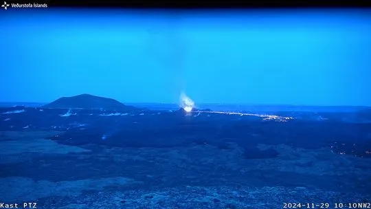
The eruption at the Sundhnúkur Crater Row continued with steady activity overnight, similar to what has been observed in recent days, with minimal changes in eruption tremor. The lava flow from the active vent is predominantly moving southeast toward Fagradalsfjall.
Experts from the Icelandic Meteorological Office measured SO₂ emissions from the eruption on November 28. Their measurements indicated that this emission rate is 64–71 kg/s. Thus, gas pollution from the eruption is expected to persist in the coming days, potentially causing discomfort or health risks, especially on hiking paths near Fagradalsfjall and close to the eruption site. Weather forecasts for gas dispersal are provided bythe weather monitoring service.
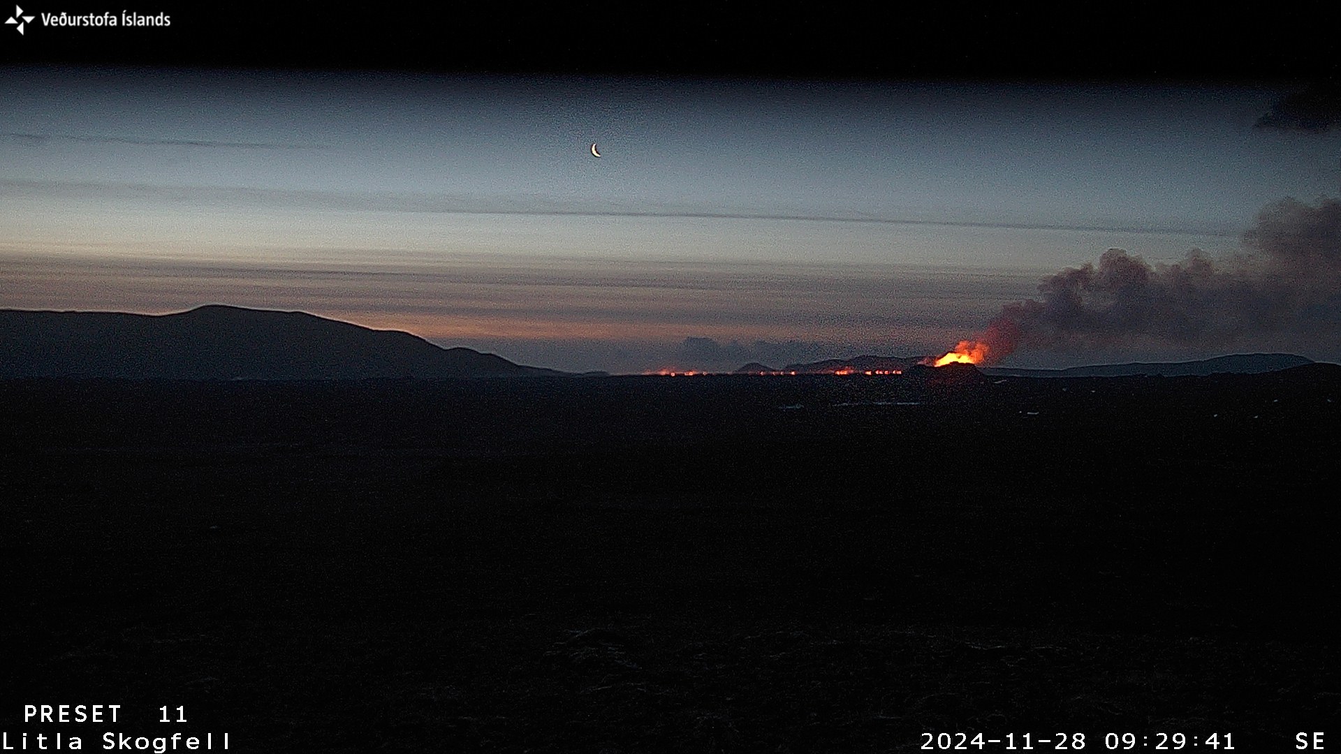
Photo taken at 10:10 AM this morning from the IMO's webcam, installed yesterday on the western side of Fagradalsfjall, facing northwest towards the active vent and the lava river flowing southeast.
Experts from the Icelandic Institute of Natural History conducted measurements and aerial surveys at the eruption site yesterday. Results indicate that the lava field from this eruption now covers 9.1 km², with a volume of approximately 47 million m³ and an average thickness exceeding 5 meters.
This eruption, which began nine days ago, is now the second largest by volume among eruptions at the Sundhnúkur Crater Row since December 2023.
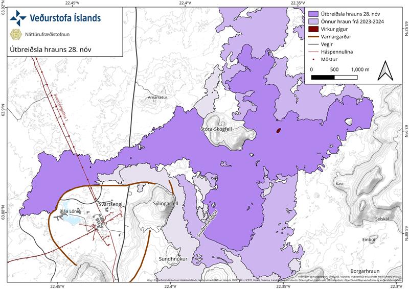
A map showing the extent of the lava field from this eruption as it was on November 28 and the location of the active vent. It also shows the lava fields that have formed in the area during the series of recent eruptions that have occurred since December 2023 (lighter purple layers). The extent of the lava field is based on measurements by the Icelandic Institute of Natural History.
The lava field that formed during the August 22 to September 5 eruption, which lasted approximately 15 days, is the largest by volume, extruding approximately 61 million m³ of lava. The lava field formed during the eruption from May 29 to June 22 is the third largest, extruding around 45 million m³.
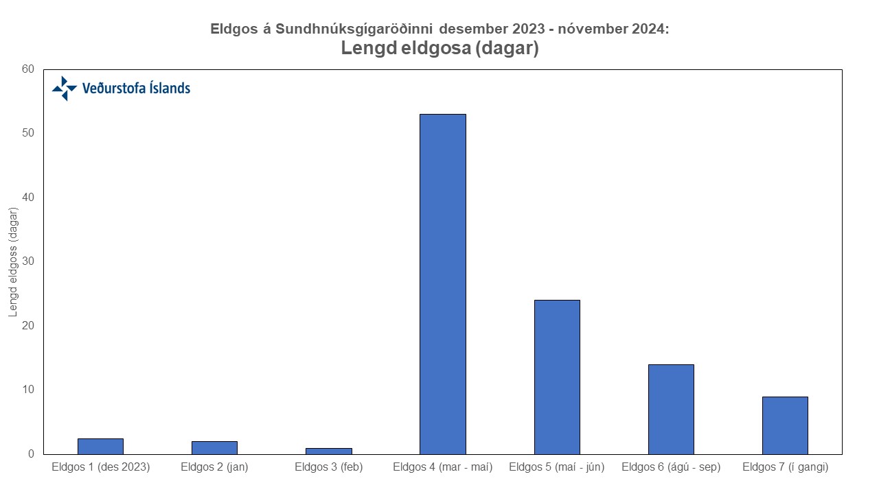
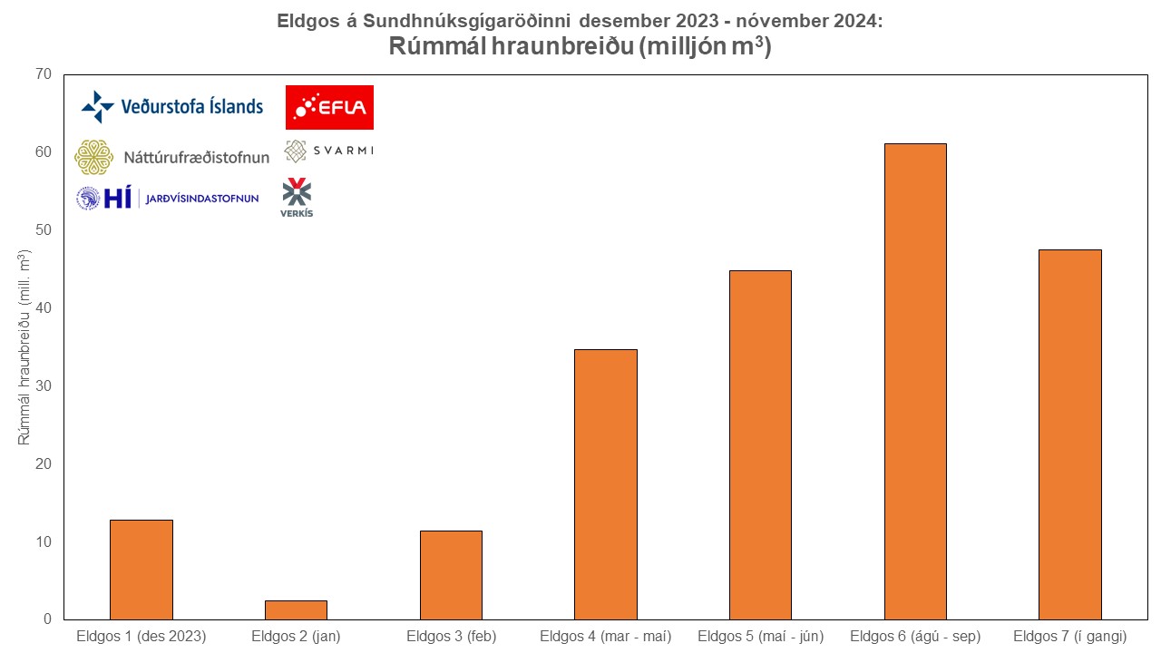
The upper graph shows the duration of eruptions on the Sundhnúkur Crater Row since December 2023 in days. The lower graph shows the volumes of the lava fields formed during these eruptions. Volumetric calculations are a result of collaboration among several parties and based on data from the Icelandic Institute of Natural History, Eflu, Verkís, Svarmi, and the Icelandic Meteorological Office.
Deformation measurements in the Svartsengi area show minimal daily changes, suggesting that magma inflow into the accumulation zone beneath Svartsengi remains consistent with the outflow from the eruption.
Based on measurements taken by the Icelandic Institute of Natural History, the average lava flow rate was approximately 11 m³/s from November 23 to 28. Based on SO₂ measurements from yesterday, the flow rate was estimated to be 7–8 m³/s. Current lava flow is roughly estimated to be 5–10 m³/s.
The Icelandic Meteorological Office has updated the hazard assessment for the eruption, valid until 3:00 PM on December 3, unless conditions change. Overall hazard levels remain unchanged in all areas. The hazard level for Zone 4 (Grindavík) remains unchanged, but there is one change for Zone 1 (Svartsengi), where the gas pollution hazard is now assessed as significant rather than very high.

Updated 28. November at 15:50 UTC
Lava is flowing mostly east and southeast
Activity remains steady, with the eruption continuing from a single vent
A significant decrease in the rate of subsidence around Svartsengi has been observed
Gas pollution is drifting southwest towards Grindavík. See gas dispersion forecast here
Eruptive activity has been steady over the last 24 hours, with lava now flowing predominantly east and southeast, towards and along the base of Fagradalsfjall. The lava field near Fagradalsfjall has expanded slightly but continues to thicken. Volcanic tremor has remained stable alongside eruptive activity in the vent. The rate of subsidence around Svartsengi has significantly reduced. However, because daily changes are minor, the trend of deformation measurements must be monitored over the next several days to determine whether uplift has resumed.
Photo captured this morning by a webcam at Litla-Skógfell. The camera faces southeast, showing the active vent on the right and the lava flow moving toward Fagradalsfjall on the left.
Northeasterly winds of 10-15 m/s are expected in Reykjanes today (Thursday), directing gas pollution southwest toward Grindavík. Winds are expected to calm this evening, increasing the likelihood of pollution being noticed widely across Reykjanes. Northeasterly winds will strengthen again tomorrow (Friday), with gas once more drifting toward Grindavík. No wildfires are anticipated in the eruption area.
Updated 27. November at 16:00 UTC
A single crater remains active, east of Stóra-Skógfell.
The lava flow continues to move eastward toward Fagradalsfjall.
Subsidence around Svartsengi has decreased, alongside diminishing volcanic activity.
Gas pollution may affect the capital region today. For further details, see the gas dispersion forecast.
Updated hazard assessment in effect until 29 November, assuming no changes.
The eruption has continued at a steady rate over the last 24 hours. Volcanic unrest remains stable, and the lava flow from the crater continues to move eastward toward Fagradalsfjall.
As volcanic activity decreases, subsidence around Svartsengi has slowed. Since day-to-day changes are minor, it is necessary to monitor the trend over several days to determine whether uplift has resumed. During the last two eruptions, it took about a week for uplift to become apparent after subsidence slowed. Thus, additional measurements over the next week will likely be needed to evaluate whether magma accumulation beneath Svartsengi will continue.
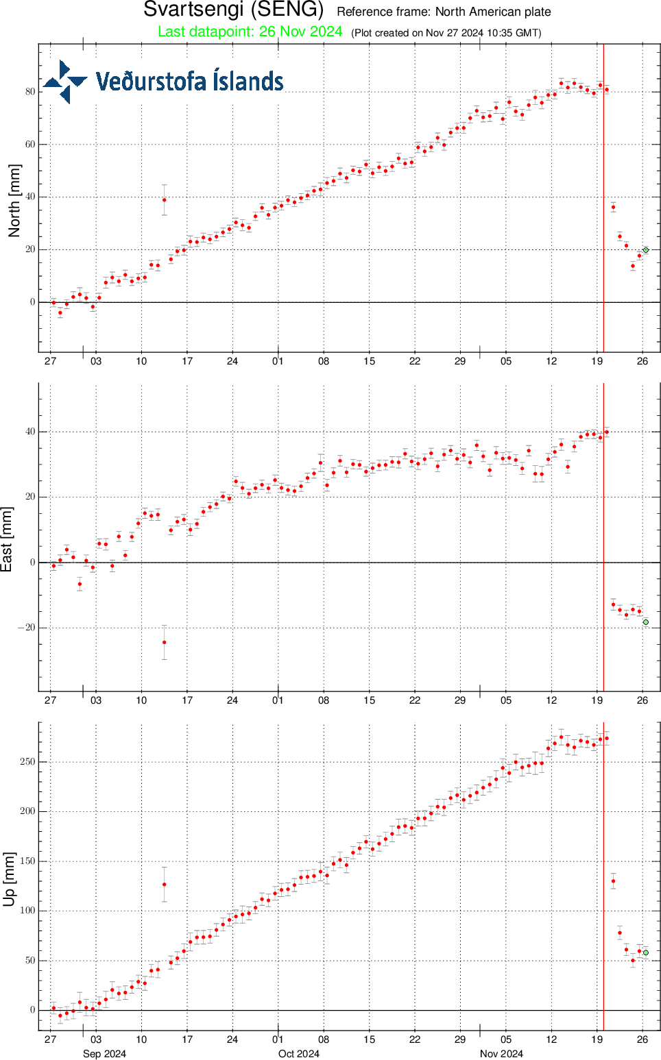
Displacements at GPS station SENG near Svartsengi over the past 90 days in the north, east, and vertical directions (top, middle, bottom). The lower graph shows vertical elevation changes in millimetres, with yesterday's (26 November) measurement marked by a green dot. The red line indicates the start of the eruption.
Our gas dispersion forecast estimates southwest winds today (Wednesday), carrying pollution north-eastward, possibly to the capital region. This evening, winds will shift to the west and later northwest, directing the pollution eastward and then south-eastward. Tomorrow (28 November), northeast winds are forecasted, which will carry pollution south-westward. Moss-fires at the eruption site are not expected. The gas dispersion forecast can be accessed here, and air quality information is available on the Environmental Agency's website.
The Icelandic Meteorological Office has issued an updated hazard assessment that is valid until 15:00 on 29 November, assuming no significant changes. Based on the eruption's development over the past few days and the gas dispersion forecast, the hazard assessment has been revised from the previous version.
The main changes involve Zone 1 (Svartsengi), where the overall hazard level is now assessed as considerable (amber) instead of high (red), and Zone 4 (Grindavík), where the overall hazard level has been downgraded from considerable (amber) to moderate (yellow).
In Zone 1 (Svartsengi), the risk of lava flow and gas pollution remains high, but the risk of tephra fall has been downgraded to moderate from considerable. For Zone 4 (Grindavík), the only change is that the risk of gas pollution is now assessed as "considerable," down from "very high." According to the gas dispersion forecast, there is a likelihood of gas pollution in Grindavík on 29 November.

Updated 26. November at 19:00 UTC
Activity at the eruption site has been relatively stable since yesterday. Eruption tremor has remained consistent since yesterday, in conjunction with steady eruptive activity at the active vent overnight. Currently, activity is confined to the northernmost vent, located directly east of Stóra-Skógfell. The majority of lava from this vent is flowing eastward toward Fagradalsfjall.
It cannot be ruled out that lava may still be flowing beneath the solidified surface of the lava field that extended westward toward Svartsengi, despite no visible movements being observed in that part of the lava field overnight.
As volcanic activity diminishes, subsidence at Svartsengi is also decreasing. However, it cannot be definitively stated whether uplift has resumed, despite the most recent GNSS measurement points indicating changes in that direction. Since daily changes are so small, conclusions cannot be drawn from individual data points; instead, trends over a period of several days must be examined. In the last two eruptions, subsidence decreased gradually for over a week before uplift became measurable again. Therefore, it is likely that up to a week of additional measurements will be required before it can be determined whether uplift and magma accumulation beneath Svartsengi will resume.
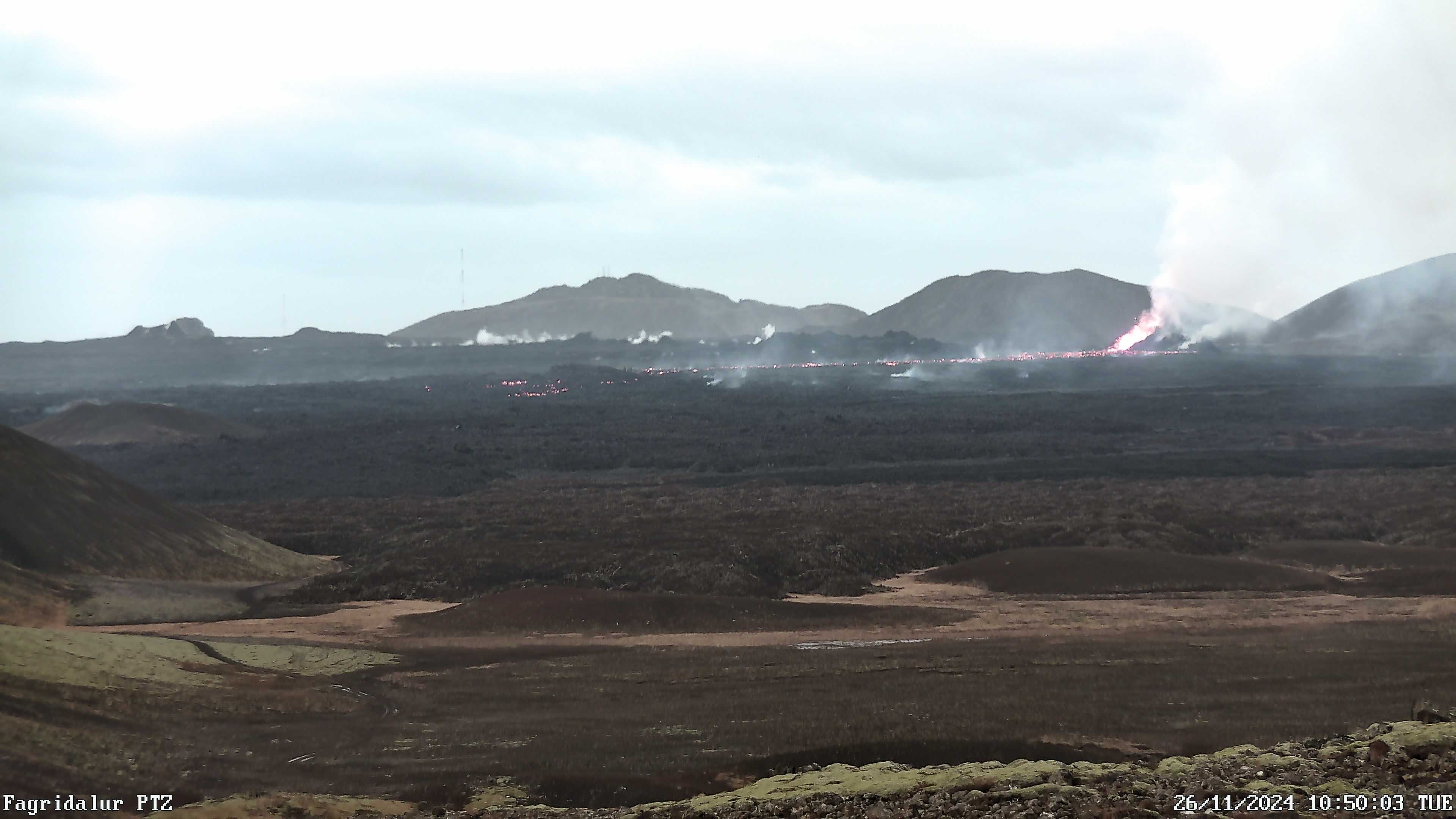
A photo taken this morning by the Icelandic Meteorological Office's webcam, showing the active vent and the lava flow from it. The camera is located in Fagridal, just north of Fagradalsfjall.
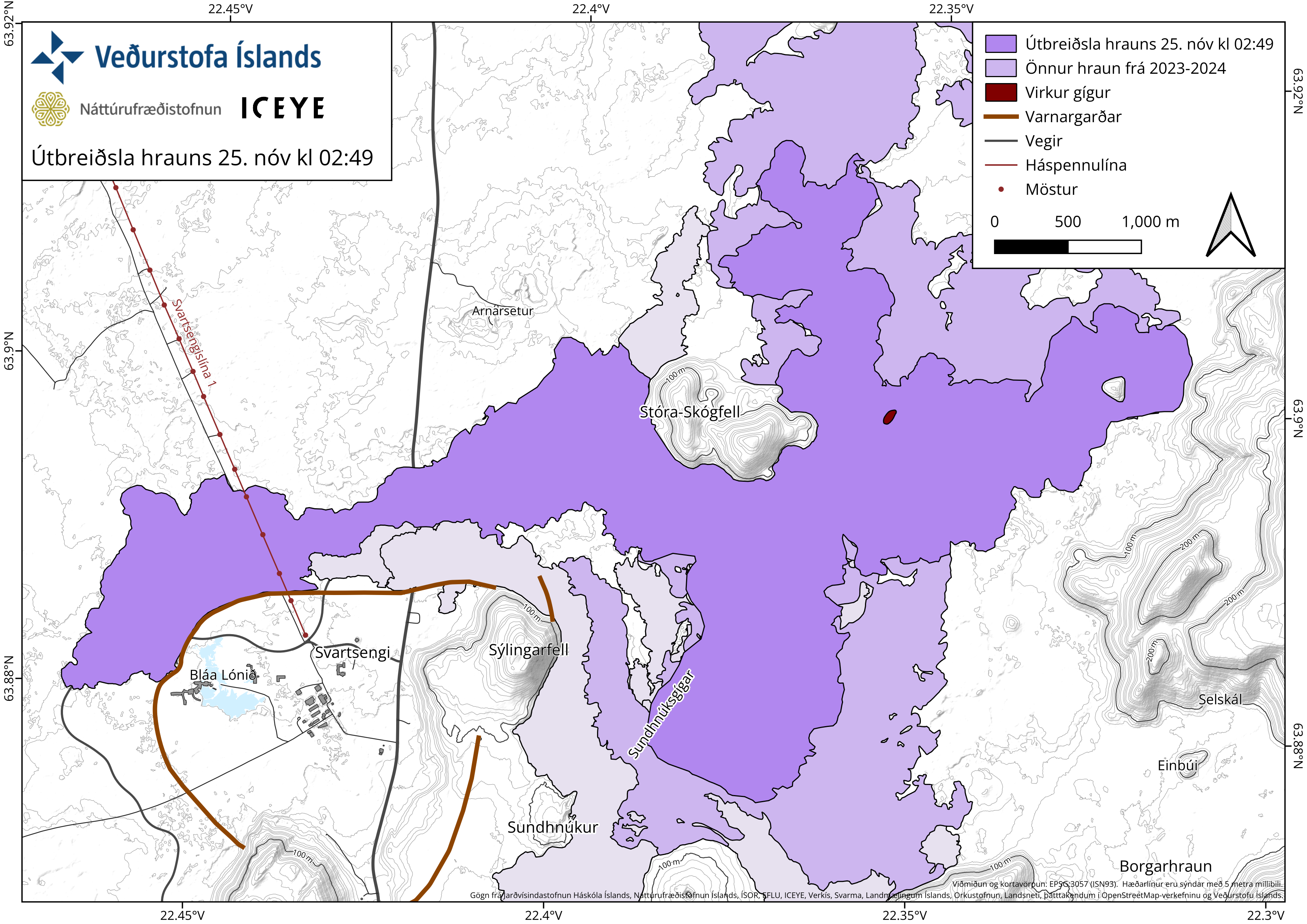
The attached map, based on data from aerial surveys by the Icelandic Institute of Natural History and satellite data from Iceye, shows the extent of the lava field formed during this eruption, as it was at 02:49 yesterday, November 25.

Funny Tee Collections - Laugh You *ss Off and Look Damn Google While doing...
teevibeusa.com/blogs/blog/funny-tee-collection-lau…