
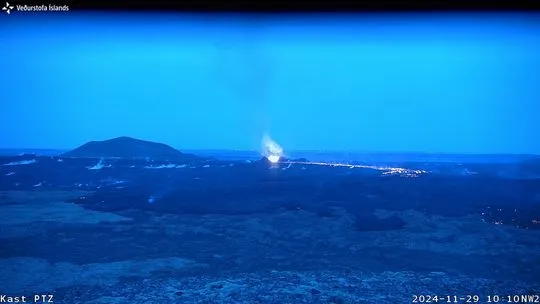
 Webcam image of the eruption
The eruption that ceased activity December 9 was the second-largest since December 2023
Updated 19. December at 17:00 UTC
Area of lava covers 9 km2 and total volume erupted is around 49 million m3
Ongoing magma accumulation underneath the Svartsengi region
The likelihood for a dike propagation will increase in the next few weeks if the magma accumulation rate remains unchanged
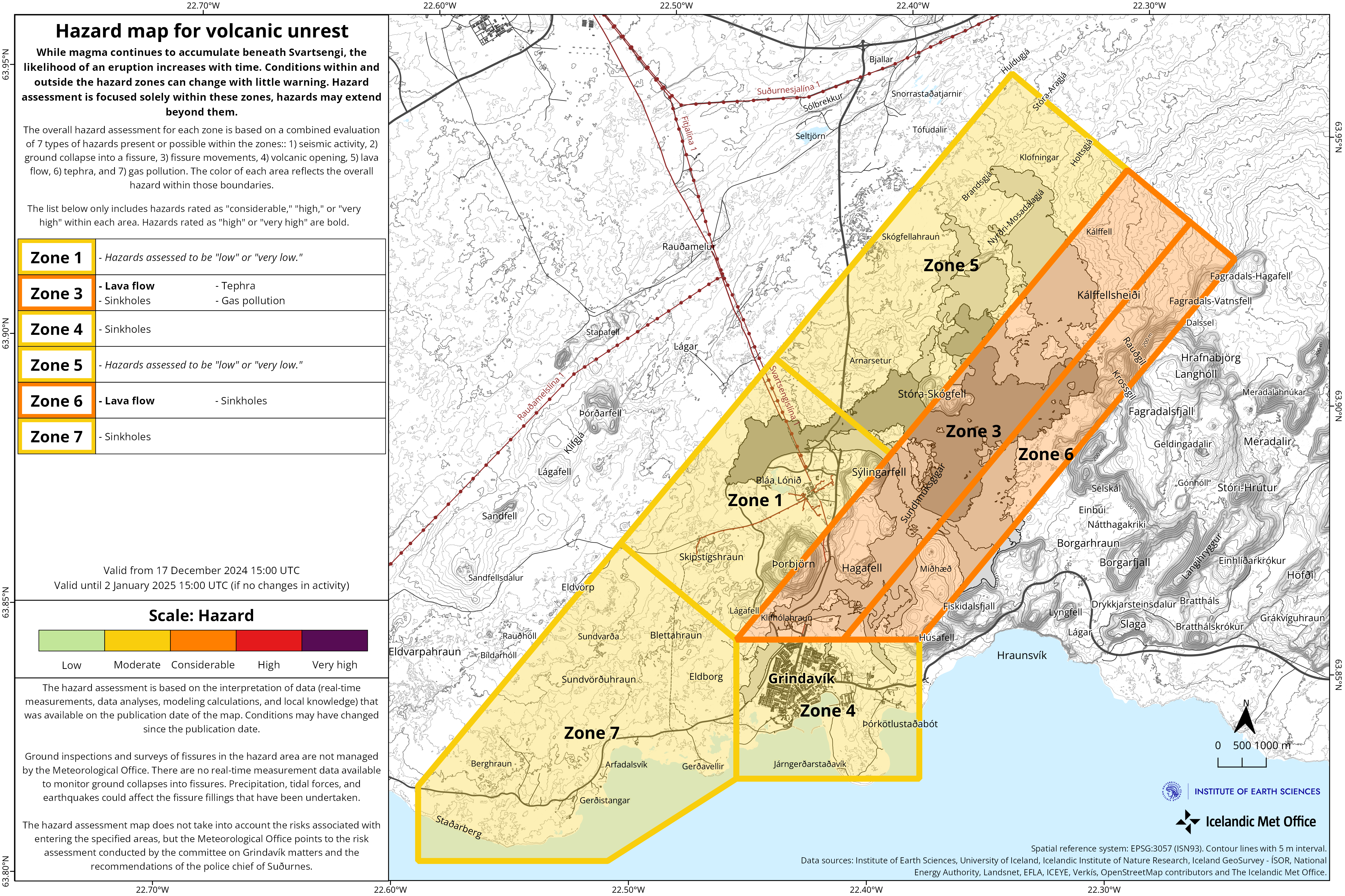
The hazard assessment has been updated, and it is valid until 2 January 2025
Considerable hazard is still assessed at the eruption site
A photogrammetric survey was conducted by the Icelandic Institute of Natural History and Survey of Iceland in a flight over the eruption site 13 December. The data reveals that the lava field that was formed during the last eruption (20 November to 9 December) had a total volume of 49,3 million cubic meters erupted and covered an area of 9,0 square kilometers. The thickest part of the lava field was around the craters and close to the barriers by the Blue Lagoon but the average thickness of the lava was 5,5 meters.
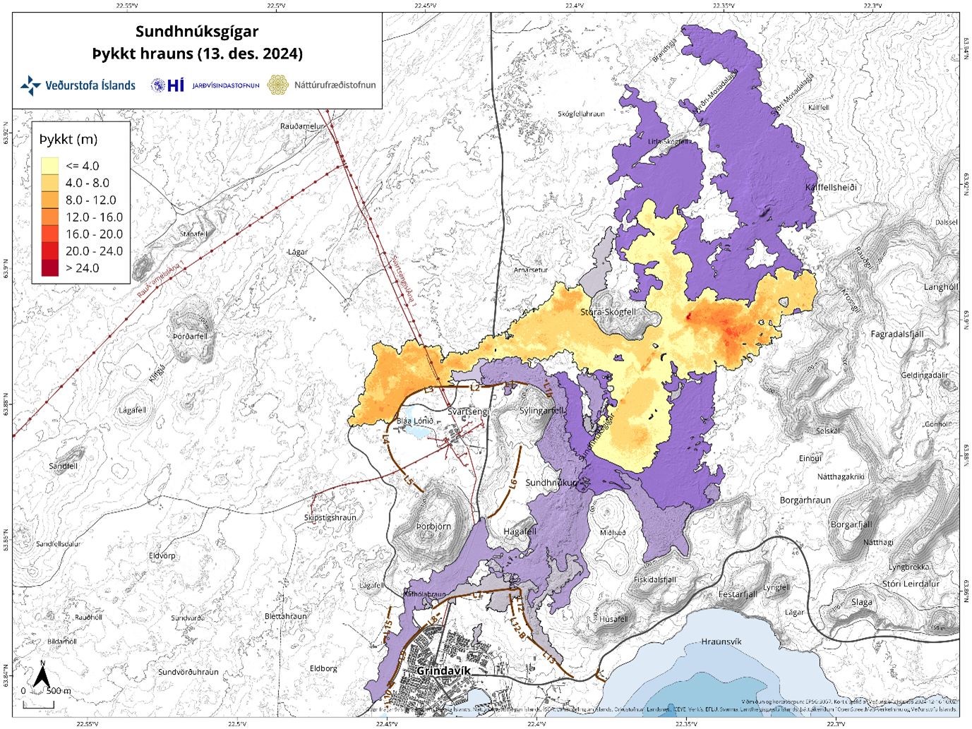 A lava thickness map showing the product of the last eruption (20 November – 9 December). The map is based on photogrammetric data from Náttúrufræðistofnun and Landmælingar Íslands which flew over the eruption site on 13 December. The yellow area represents the newest lave field and the purple are lava fields formed in eruptions in the past year.
This eruption, which lasted for eighteen days, was the second largest eruption in volume size compared to the previous eruptions on the Sundhnúkar crater row. The largest eruption (22 August – 5 September) had a volume of 61,3 million cubic meters and area of 15,8 square kilometers (see graph).
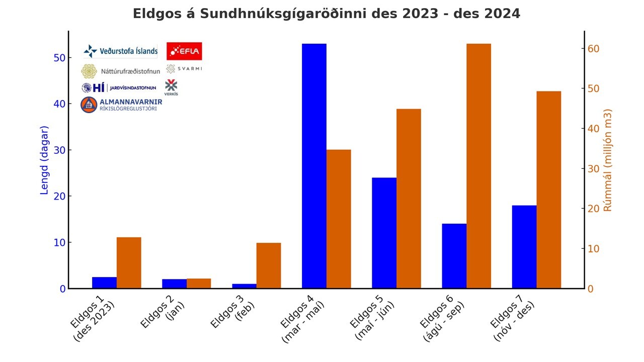 The graph compares the duration (blue) and volume (orange) of the eruptions on the Sundhnúkur crater row from December 2023. The data is a collaboration based on collective data from the Icelandic Civil Protection, Náttúrufræðistofnun, Efla, Verkís, Svarmi and the Icelandic Met Office.
Yesterday, December 18, marked one year since the first eruption in this sequence of events along the Sundhnúksgígar fissure system began. Since then, a total of seven eruptions have occurred, lasting a combined 114 days and producing approximately 216 million cubic meters of lava flows.
 A lava waterfall formed during the eruption that began on December 18, 2023. Photo: Halldór Björnsson/IMO.
GPS data shows that the uplift in Svartsengi continues at a similar rate. This suggests that magma accumulation also continues steadily. Considering the data available, it is estimated that magma accumulation will need to continue at a similar rate for at least some weeks before the likelihood of a dike intrusion increases. If changes occur in the magma accumulation rate, this estimate will change. The IMO continues to monitor the activity in the area closely and if significant changes occur in the magma accumulation rate or the level of seismic activity, new information will be published.
The Icelandic Meterological Office has issued an updated hazard map which is valid until the 2 January 2025, unless circumstances change. The update mainly affects area 3 (Sundhnúks crater row), where the hazard level is now assessed to be considerable (orange) whereas it was high (red) before.
 Click to enlarge

Funny Tee Collections - Laugh You *ss Off and Look Damn Google While doing...
teevibeusa.com/blogs/blog/funny-tee-collection-lau…